Alum Cave Bluff & Arch Rock
Alum Cave Bluff.
Written By: Shawn Dunnaway
Exploration Date: June 17, 2014
Weather: Mostly sunny, upper 70s.
Elevation: 3,834′ at parking lot, 4,389′ at Arch Rock, 4,970 at the bluff
Alum Cave Bluff GPS: 35.63934, -83.447471
Alum Cave Bluff Trailhead on US 441 GPS: 35.629553, -83.451443
By my best calculation it had been nearly 20 years since I had seen Alum Cave Bluff. My wife had never been so we decided it was time to hit the trail and see what we could find.
Alum Cave Bluff trail is the most beautiful trail I have experienced in the Smoky Mountains. The national park’s assortment of plant and animal life is showcased here with abundance of all things nature. The word “biodiversity” comes to mind.
The first 1.4 miles of the trail offered a gentle incline along Alum Cave Creek. An old-growth forest of hemlock, yellow birch and blooming rhododendron provided a welcoming shade from that warm summer day.
The trail paralleled the creek for the entire first leg of the journey to Arch Rock. Along the creek-side trail there were many spots to stop and gawk at the beautiful scenery of the creek’s cascades.
We couldn’t help but notice the rather unusual temperature changes along the trail. There were a mix of warm and cool breezes and we would run into “cold spots” in random places. Of course the higher we went the cooler it got, but the temperature fluctuations were noteworthy along the trail.
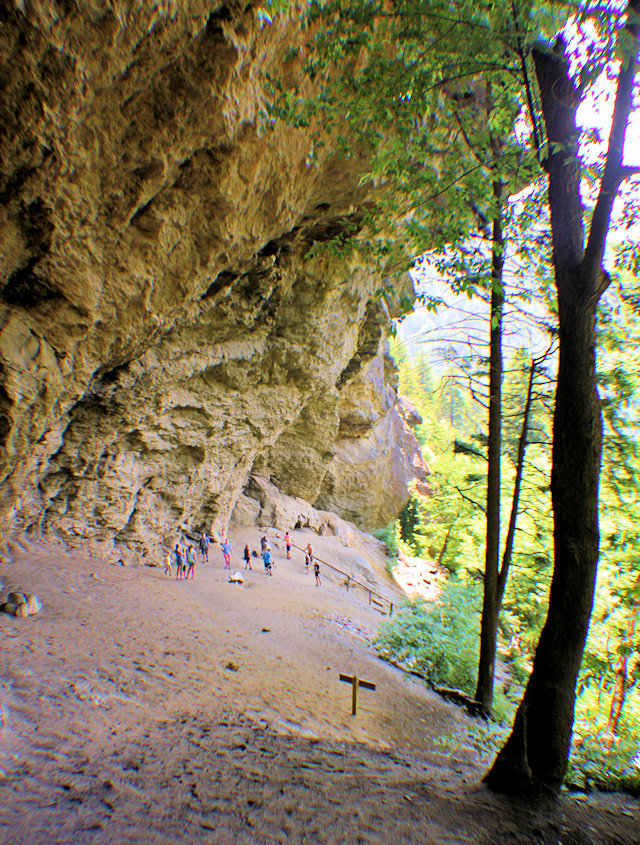
Once at Arch Rock, we stopped for a while and took some pictures of this strange rock formation.
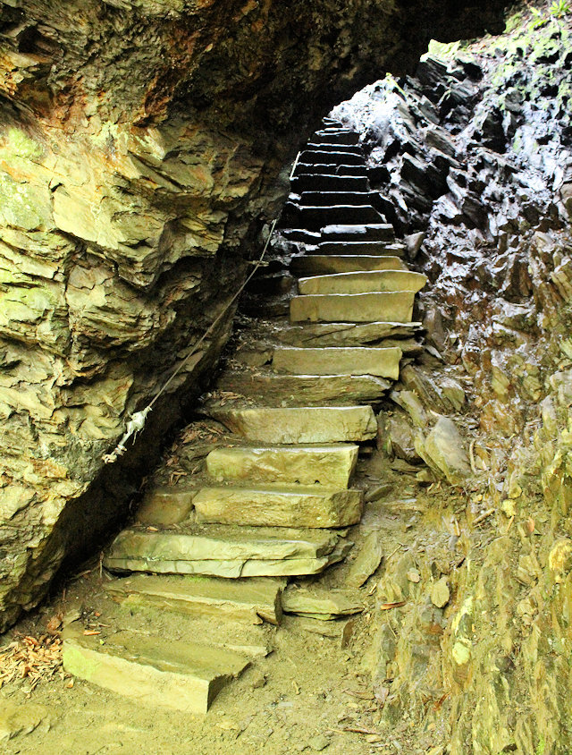
A winding stone staircase heads through Arch Rock, located about 1.4 miles down Alum Cave Bluff trail.
Naturally occurring, it is what I would describe as a cross between a natural bridge and a cave. A rock staircase was constructed through the rock that allowed people to continue through to Alum Cave Bluff.
A quick note about the stairs on Arch Rock: they were steep and wet. While a cable offers a crude handrail while climbing the stairs, it was a little challenging getting through there.
From Arch Rock the trail became strenuous. The final 0.9-mile leg is tough and steep. Being out of shape, I had to stop probably four or five times along the way. At times the trail was solid rock, especially at Inspiration Point, which was right before the bluff. Inspiration Point offered a beautiful overlook, so we stopped and got some photos.
Just a couple tenths of a mile or so past inspiration point was Alum Cave Bluff. This place isn’t a cave, but what is known in the geology world as a “rock shelter”. It sticks out over your head 80 feet above and out maybe 40 feet. The elevation of the bluff is 4,970 feet.
The bluff has some interesting history. During the first part of the 1800s, a company established mining operations here to mine Epsom salt. Then during the Civil War, the Confederate Army mined the area for saltpeter, which they used to make gunpowder. How they transported their goods down from the cave is beyond me.
The area directly under the bluff was dirty and steep, so you might want to consider not wearing your good shoes or clothes. We found this out the hard way!
Alum Cave Bluff trail continued past the bluff itself for another 2.8 miles to Mount LeConte. On this day we just wanted to see the bluff and didn’t have the time (or energy) to head to the summit.
On the way back down, we saw a snail in the middle of the trail. It was larger than the snails we were accustomed to seeing, so we decided to do some macrophotography. We snapped a really cool close-up of him that you can see below.
Also on the trail in a hollowed out tree we saw a small Eastern worm snake, but we don’t have any photographic evidence since he was apparently camera shy.
When we reached the car our dogs were barking, not literally of course but we had that good old fashioned leg and feet pain from our 4.4-mile round-trip hike.
The trail to Arch Rock has a moderate rating and we found it really easy to hike. The trail took a strenuous turn from Arch Rock to Alum Cave Bluff and it was much more difficult. The elevation change from the parking lot to the bluff is 1136 feet.
We took our six-year-old with us and he held out fine, probably better than we did. So I think it would be alright to take your kids with you, just make sure you keep a close watch on them especially through Arch Rock and along the rocky portions of the trail that contain a hand cable.
Reflecting back, Alum Cave Bluff Trail is a hike I would highly recommend. In fact, if you could just do one longer trail during your next trip to the Smokies, I would recommend this one over any other.

Styx Branch. The dark area, top center, is the opening of Arch Rock

Close-up of the cascades of the above photo

At the bottom of Arch Rock

Above Arch Rock

The Alum Cave Bluff Trail has many interesting features, such as this solid-rock pathway.

Along the way we found this decorative rock-stack someone constructed.

Mountain Laurel grows in the higher elevations of the trail.

Approaching Inspiration Point from the Alum Cave Bluff.

Moss is everywhere. Here water continuously drips from the rocks and moss.

At Alum Cave Bluff, a close-up of a portion of the view

This family enjoyed hiking the trail to Alum Cave Bluff.

Here an old tree is getting reclaimed by the forest floor.

Here is the snail we found along the trail.

There were several squirrels along the trail as well.