Travel Tools
Getting to the Smokies – Alternative Routes

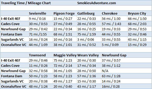
Mileage chart for Smoky Mountain area communities and points of interest. Travel times vary due to traffic congestion. Click the image to enlarge.
Most travelers arrive at the Smoky Mountains from the east or west using Interstate 40. The traditional exit to the Smokies is Exit 407 of Interstate 40, just east of Knoxville, Tennessee. This highway is known as Tennessee 66, and it is the most direct route from I-40 into Sevierville, Pigeon Forge, and Gatlinburg. From the exit, it is approximately eight miles to Sevierville, 13 miles to Pigeon Forge, 22 miles to Gatlinburg, and 37 miles to Newfound Gap in the National Park.
This six-lane highway can occasionally be very congested. If you think traffic may be bad during the time you are traveling, consider these two alternate routes – US 321 at I-40 (Exit 364) and US 441 at Exit 388 in Knoxville, if you are traveling from the west.
The drive to Gatlinburg, Tennessee, from US 321 at I-40 is approximately 68 miles and will take you through Maryville and Townsend. US 441 in Knoxville is approximately 38 miles from Gatlinburg.
Bypassing Pigeon Forge Due to Heavy Traffic
Occasionally traffic in Pigeon Forge can get congested, especially for events such as the annual Rod Run. If you encounter very heavy, nearly stand-still traffic in or near Pigeon Forge, use the six-lane Veterans Boulevard (Tennessee 449) to bypass Pigeon Forge.
Bypassing Gatlinburg Due To Heavy Traffic
Before you enter Gatlinburg, heading south on US 441, you can use the two-lane Gatlinburg Bypass to get around the city if you are heading straight into the National Park. The bypass offers scenic overlooks of Gatlinburg and is the quickest way to the National Park from Pigeon Forge, especially during heavy traffic.
Accessibility in the Smokies
Do you have special mobility needs? Read our section on Accessibility in the Smokies.
Trolley Maps
Looking for public transportation around Gatlinburg or Pigeon Forge? Check out our downloadable trolley maps.
